
HOMELOFT BASICS
1857 Nautical Chart of St Clair Flats Lake St Clair (Material: 20" x 24" Matte)
£80.56
£134.28
-
 Order within to get between
 -
 Tracked Shipping on All Orders
-
 14-Day Returns
- Secure Payments
-
 24/7 Customer Support
Description
- Made by GenealogicalSurveyor
- The Genealogical Surveyor - Historical Map Prints
- Location: Saint Augustine Beach, Florida
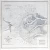
1857 Nautical Chart of St Clair Flats Lake St Clair
20" x 24" or 30" x 36" Full Color Map
Plotted on Heavy Weight Archival Matte Paper or Fine Art Canvas.
Canvas has an additional one inch white border all the way around for mounting if needed.
This map shows water depths, shore line detail, channels, place names, and more.
Great for display & research!
Shipping and Returns
- We offer tracked shipping on all orders. Tracking information will be shared as soon as the order is dispatched.
- Please check the delivery estimate before adding a product to the cart. This is displayed for every product on the website.
- Available shipping methods and charges will be displayed at the time of checkout, depending on your exact location.
- All customers are entitled to a return window of 14 days, starting from the date of delivery of the product(s).
- Customers are advised to read our return policy for details of the return process, eligibility, refunds as well as cancellations or exchanges.
- In case of any issues or concerns about Shipping or Returns, please contact us and we will be happy to help.
HomeLoft Basics.
1857 Nautical Chart of St Clair Flats Lake St Clair (Mate...
£80.56
£134.28