
HISTORIC PRINTS
18" x 24" 1981 Map Of Maine National Cooperative Soil Survey
£112.80
£188.00
Save 40% (£75.20)
-
 Order within 4 hours and 4 minutes to get between May 16 - May 22
 -
 Tracked Shipping on All Orders
-
 14-Day Returns
- Secure Payments
-
 24/7 Customer Support
Description
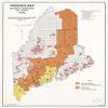
Progress map, national cooperative soil survey, Maine. "Source: Maine Highway Commission minor civil divisions map, 1967, U.S.G.S. topo sheets." In lower left corner: March 1981. Indexed for soil survey publication areas. "1 10.761."Shipping and Returns
- We offer tracked shipping on all orders. Tracking information will be shared as soon as the order is dispatched.
- Please check the delivery estimate before adding a product to the cart. This is displayed for every product on the website.
- Available shipping methods and charges will be displayed at the time of checkout, depending on your exact location.
- All customers are entitled to a return window of 14 days, starting from the date of delivery of the product(s).
- Customers are advised to read our return policy for details of the return process, eligibility, refunds as well as cancellations or exchanges.
- In case of any issues or concerns about Shipping or Returns, please contact us and we will be happy to help.
Historic Prints.
18" x 24" 1981 Map Of Maine National Cooperative Soil Survey
£112.80
£188.00
Save 40.0% (£75.20)