
HISTORIC PRINTS
18" x 24" 1976 Map Of Allegheny National Forest Pennsylvania
£112.80
£188.00
Save 40% (£75.20)
-
 Order within 4 hours and 4 minutes to get between May 16 - May 22
 -
 Tracked Shipping on All Orders
-
 14-Day Returns
- Secure Payments
-
 24/7 Customer Support
Description
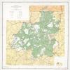
Allegheny National Forest, Pennsylvania. Relief shown by spot heights. "Forest Service map class A." Printed by "*U.S. Government Printing Office: 1976--654-510". Rubber-stamped at lower right: Geography and Map Division, Library of Congress, Hammond Collection-2003. Imperfect: Use-worn, torn at fold lines. Includes source-materials diagram and location map (inset). Text, "Recreation sites index" table, 10 campground maps, and col. ill. on verso.Shipping and Returns
- We offer tracked shipping on all orders. Tracking information will be shared as soon as the order is dispatched.
- Please check the delivery estimate before adding a product to the cart. This is displayed for every product on the website.
- Available shipping methods and charges will be displayed at the time of checkout, depending on your exact location.
- All customers are entitled to a return window of 14 days, starting from the date of delivery of the product(s).
- Customers are advised to read our return policy for details of the return process, eligibility, refunds as well as cancellations or exchanges.
- In case of any issues or concerns about Shipping or Returns, please contact us and we will be happy to help.
Historic Prints.
18" x 24" 1976 Map Of Allegheny National Forest Pennsylvania
£112.80
£188.00
Save 40.0% (£75.20)