
HISTORIC PRINTS
18" x 24" 1881 Map of Chicago Burlington & Quincy Rail Road & Connecting Lines
£111.93
£186.55
-
 Order within to get between
 -
 Tracked Shipping on All Orders
-
 14-Day Returns
- Secure Payments
-
 24/7 Customer Support
Description
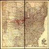
- Correct map of the Chicago, Burlington, and Quincy Rail Road and its principal connecting lines.
- Print size: 18 x 24 inches | Archival, professional quality print on premium matte paper
- Beautiful Historic Prints | Quality Reproduction
- Perfect for the Home or Office. Makes a great gift!
- Made in USA. Ships from USA | 100% Satisfaction Guaranteed
Map of the United States, eastern and western sheets, with relief by hachuring, drainage, cities and towns, county boundaries, and Indian reservations. The railroad network is overprinted in red. Heavy red lines indicate main line of the Chicago, Burlington, and Quincy Railroad.
Shipping and Returns
- We offer tracked shipping on all orders. Tracking information will be shared as soon as the order is dispatched.
- Please check the delivery estimate before adding a product to the cart. This is displayed for every product on the website.
- Available shipping methods and charges will be displayed at the time of checkout, depending on your exact location.
- All customers are entitled to a return window of 14 days, starting from the date of delivery of the product(s).
- Customers are advised to read our return policy for details of the return process, eligibility, refunds as well as cancellations or exchanges.
- In case of any issues or concerns about Shipping or Returns, please contact us and we will be happy to help.
Historic Prints.
18" x 24" 1881 Map of Chicago Burlington & Quincy Rail Ro...
£111.93
£186.55