
HISTORIC PRINTS
18" x 24" 1876 Topographic Map of Gratiot County Michigan
£111.93
£186.55
-
 Order within to get between
 -
 Tracked Shipping on All Orders
-
 14-Day Returns
- Secure Payments
-
 24/7 Customer Support
Description
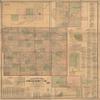
Topographic map of Gratiot Co., Michigan, "Entered according to Act of Congress A.D. 1876 by F.W. Beer & Co. in the Office of the Librarian of Congress at Washington." Includes business directories, distance table, statistical table of U.S., principle governments of the world, insets of Alma, St. Louis, Estella, Elm Hall, Riverdale, Bridgeville, Pompeh, diagram of Gratiot County, Ithaca, Breckenridge, views of public, residential, and commercial properties.Shipping and Returns
- We offer tracked shipping on all orders. Tracking information will be shared as soon as the order is dispatched.
- Please check the delivery estimate before adding a product to the cart. This is displayed for every product on the website.
- Available shipping methods and charges will be displayed at the time of checkout, depending on your exact location.
- All customers are entitled to a return window of 14 days, starting from the date of delivery of the product(s).
- Customers are advised to read our return policy for details of the return process, eligibility, refunds as well as cancellations or exchanges.
- In case of any issues or concerns about Shipping or Returns, please contact us and we will be happy to help.
Historic Prints.
18" x 24" 1876 Topographic Map of Gratiot County Michigan
£111.93
£186.55