
HISTORIC PRINTS
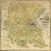
18" x 24" 1875 Map of Chatham County State of Georgia
£111.93
£186.55
-
 Order within to get between
 -
 Tracked Shipping on All Orders
-
 14-Day Returns
- Secure Payments
-
 24/7 Customer Support
Description
Map of Chatham County, state of Georgia, Cadastral map showing hydrostatic details, low and swamp lands, surveyed property lines, and key to names of surveyors whose plats make up this map. Differs from other 1875 ed. in not having text at the bottom margin.Shipping and Returns
- We offer tracked shipping on all orders. Tracking information will be shared as soon as the order is dispatched.
- Please check the delivery estimate before adding a product to the cart. This is displayed for every product on the website.
- Available shipping methods and charges will be displayed at the time of checkout, depending on your exact location.
- All customers are entitled to a return window of 14 days, starting from the date of delivery of the product(s).
- Customers are advised to read our return policy for details of the return process, eligibility, refunds as well as cancellations or exchanges.
- In case of any issues or concerns about Shipping or Returns, please contact us and we will be happy to help.
Historic Prints.
18" x 24" 1875 Map of Chatham County State of Georgia
£111.93
£186.55