
HISTORIC PRINTS
18" x 24" 1862 Map Sketch of Relative Positions of Fort Henry & Fort Donelson
£111.93
£186.55
-
 Order within to get between
 -
 Tracked Shipping on All Orders
-
 14-Day Returns
- Secure Payments
-
 24/7 Customer Support
Description
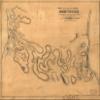
Sketch showing the relative positions of Fort Henry and Fort Donelson : with the roads connecting the two places, Shows the forts, roads, outwork fortifications in the vicinity of the forts, fortifications in the vicinity of the town of Dover, outlying buildings, and streams. Relief shown by hachures. At lower margin in handwriting: Engr. Dept. July 18/64. Recd. with Gen. Cullum's letter of the 16th inst. (C. 5621). Mounted on paper backing under gauze covering. In upper left corner: 148.D.. LC Civil War maps (2nd ed.), 412Shipping and Returns
- We offer tracked shipping on all orders. Tracking information will be shared as soon as the order is dispatched.
- Please check the delivery estimate before adding a product to the cart. This is displayed for every product on the website.
- Available shipping methods and charges will be displayed at the time of checkout, depending on your exact location.
- All customers are entitled to a return window of 14 days, starting from the date of delivery of the product(s).
- Customers are advised to read our return policy for details of the return process, eligibility, refunds as well as cancellations or exchanges.
- In case of any issues or concerns about Shipping or Returns, please contact us and we will be happy to help.
Historic Prints.
18" x 24" 1862 Map Sketch of Relative Positions of Fort H...
£111.93
£186.55