
HISTORIC PRINTS
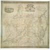
18" x 24" 1862 Map of The State of Virginia Containing The Counties Principal Towns Railroads Rivers Canals & All Other Internal Improvements
£111.93
£186.55
-
 Order within to get between
 -
 Tracked Shipping on All Orders
-
 14-Day Returns
- Secure Payments
-
 24/7 Customer Support
Description
- Map of the state of Virginia : containing the counties, principal towns, railroads, rivers, canals & all other internal improvements.
- Print size: 18 x 24 inches | Archival, professional quality print on premium matte paper
- Beautiful Historic Prints | Quality Reproduction
- Perfect for the Home or Office. Makes a great gift!
- Made in USA. Ships from USA | 100% Satisfaction Guaranteed
Map of Virginia Richmond West & Johnston View of Capitol Square, Richmond, Va. includes list of railroads.
Shipping and Returns
- We offer tracked shipping on all orders. Tracking information will be shared as soon as the order is dispatched.
- Please check the delivery estimate before adding a product to the cart. This is displayed for every product on the website.
- Available shipping methods and charges will be displayed at the time of checkout, depending on your exact location.
- All customers are entitled to a return window of 14 days, starting from the date of delivery of the product(s).
- Customers are advised to read our return policy for details of the return process, eligibility, refunds as well as cancellations or exchanges.
- In case of any issues or concerns about Shipping or Returns, please contact us and we will be happy to help.
Historic Prints.
18" x 24" 1862 Map of The State of Virginia Containing Th...
£111.93
£186.55