
HISTORIC PRINTS
16" x 24" 1889 Map of The County of Santa Barbara California
£111.93
£186.55
-
 Order within to get between
 -
 Tracked Shipping on All Orders
-
 14-Day Returns
- Secure Payments
-
 24/7 Customer Support
Description
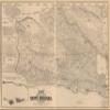
Map of the County of Santa Barbara, California, Relief shown by hachures. Cadastral map showing drainage, roads, railroads, land ownership, landowners' names, ranchos, township and section lines, school and supervisorial districts, etc.Shipping and Returns
- We offer tracked shipping on all orders. Tracking information will be shared as soon as the order is dispatched.
- Please check the delivery estimate before adding a product to the cart. This is displayed for every product on the website.
- Available shipping methods and charges will be displayed at the time of checkout, depending on your exact location.
- All customers are entitled to a return window of 14 days, starting from the date of delivery of the product(s).
- Customers are advised to read our return policy for details of the return process, eligibility, refunds as well as cancellations or exchanges.
- In case of any issues or concerns about Shipping or Returns, please contact us and we will be happy to help.
Historic Prints.
16" x 24" 1889 Map of The County of Santa Barbara California
£111.93
£186.55