
HISTORIC PRINTS
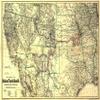
16" x 24" 1883 Map Showing The Atchison Topeka & Santa F Railroad System with Its Connections
£111.34
£185.57
-
 Order within to get between
 -
 Tracked Shipping on All Orders
-
 14-Day Returns
- Secure Payments
-
 24/7 Customer Support
Description
Map of the southwestern states from the Mississippi River to the Pacific Ocean; indicates in table form miles of lines in Kansas, Missouri, Colorado, New Mexico, Texas, Arizona, and Mexico; shows relief by hachures, drainage, state boundaries, and cities and towns.Shipping and Returns
- We offer tracked shipping on all orders. Tracking information will be shared as soon as the order is dispatched.
- Please check the delivery estimate before adding a product to the cart. This is displayed for every product on the website.
- Available shipping methods and charges will be displayed at the time of checkout, depending on your exact location.
- All customers are entitled to a return window of 14 days, starting from the date of delivery of the product(s).
- Customers are advised to read our return policy for details of the return process, eligibility, refunds as well as cancellations or exchanges.
- In case of any issues or concerns about Shipping or Returns, please contact us and we will be happy to help.
Historic Prints.
16" x 24" 1883 Map Showing The Atchison Topeka & Santa F ...
£111.34
£185.57