
HISTORIC PRINTS
16" x 24" 1868 Map of Pleasant Plains & Mount Pleasant Washington DC Suburbs
£111.93
£186.55
-
 Order within to get between
 -
 Tracked Shipping on All Orders
-
 14-Day Returns
- Secure Payments
-
 24/7 Customer Support
Description
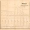
- Todd & Brown's subdivision of part of "Pleasant Plains & Mt. Pleasant," suburbs of Washington D.C.
- Print size: 16 x 24 inches | Archival, professional quality print on premium matte paper
- Beautiful Historic Prints | Quality Reproduction
- Perfect for the Home or Office. Makes a great gift!
- Made in USA. Ships from USA | 100% Satisfaction Guaranteed
Todd & Brown's subdivision of part of "Pleasant Plains & Mt. Pleasant," suburbs of Washington D.C. Cadastral map. "April 1868." Oriented with north to the right. LC copy 1 fold-lined, missing small sections at edges, and mounted on cloth backing. LC copy 2 stained, brittle, and missing small sections at edges.
Shipping and Returns
- We offer tracked shipping on all orders. Tracking information will be shared as soon as the order is dispatched.
- Please check the delivery estimate before adding a product to the cart. This is displayed for every product on the website.
- Available shipping methods and charges will be displayed at the time of checkout, depending on your exact location.
- All customers are entitled to a return window of 14 days, starting from the date of delivery of the product(s).
- Customers are advised to read our return policy for details of the return process, eligibility, refunds as well as cancellations or exchanges.
- In case of any issues or concerns about Shipping or Returns, please contact us and we will be happy to help.
Historic Prints.
16" x 24" 1868 Map of Pleasant Plains & Mount Pleasant Wa...
£111.93
£186.55