
HISTORIC PRINTS
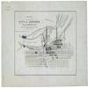
14" x 24" 1865 Map of A Part of The City of Richmond Showing The Burnt Districts
£104.46
£174.10
-
 Order within to get between
 -
 Tracked Shipping on All Orders
-
 14-Day Returns
- Secure Payments
-
 24/7 Customer Support
Description
- Map of a part of the city of Richmond showing the burnt districts
- Print size: 14 x 24 inches | Archival, professional quality print on premium matte paper
- Beautiful Historic Prints | Quality Reproduction
- Perfect for the Home or Office. Makes a great gift!
- Made in USA. Ships from USA | 100% Satisfaction Guaranteed
Shows an area north of the James River surrounding the capitol and includes street names.
Shipping and Returns
- We offer tracked shipping on all orders. Tracking information will be shared as soon as the order is dispatched.
- Please check the delivery estimate before adding a product to the cart. This is displayed for every product on the website.
- Available shipping methods and charges will be displayed at the time of checkout, depending on your exact location.
- All customers are entitled to a return window of 14 days, starting from the date of delivery of the product(s).
- Customers are advised to read our return policy for details of the return process, eligibility, refunds as well as cancellations or exchanges.
- In case of any issues or concerns about Shipping or Returns, please contact us and we will be happy to help.
Historic Prints.
14" x 24" 1865 Map of A Part of The City of Richmond Show...
£104.46
£174.10