
HISTORIC PRINTS
10" x 24" 1829 Map Of Florida Territory Connected To Mississippi Delta Atlantic Gulf Of Mexico & Bay Of Espiritu Santo & From Saint Marys Harbour To Saint Augustine
£94.63
£157.72
-
 Order within to get between
 -
 Tracked Shipping on All Orders
-
 14-Day Returns
- Secure Payments
-
 24/7 Customer Support
Description
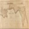
- Map of the territory of Florida, from its northern boundary to lat. 2730N, connected with the delta of the Mississippi : annexed to the report of the Board of Internal Improvement dated Febr. 19th, 1829, relating to the canal contemplated to connect the Atlantic with the Gulf of Mexico and describing the inland navigation parallel to the coast from the Mississippi to the Bay of Espiritu Santo and from St. Mary's Harbour to St. Augustine
- Print size: 10 x 24 inches | Archival, professional quality print on premium matte paper
- Beautiful Historic Prints | Quality Reproduction
- Perfect for the Home or Office. Makes a great gift!
- Made in USA. Ships from USA | 100% Satisfaction Guaranteed
Map of the territory of Florida, from its northern boundary to lat. 2730N, connected with the delta of the Mississippi : annexed to the report of the Board of Internal Improvement dated Febr. 19th, 1829, relating to the canal contemplated to connect the Atlantic with the Gulf of Mexico and describing the inland navigation parallel to the coast from the Mississippi to the Bay of Espiritu Santo and from St. Mary's Harbour to St. Augustine. Covers portions of southern states of Florida, Alabama, Mississippi, and Louisiana. Depths shown by soundings. Includes 2 profile charts displaying elevations, area map that extends southward into Gulf of Mexico and Caribbean regions, and 13 insets that show entrances to bays and rivers.
Shipping and Returns
- We offer tracked shipping on all orders. Tracking information will be shared as soon as the order is dispatched.
- Please check the delivery estimate before adding a product to the cart. This is displayed for every product on the website.
- Available shipping methods and charges will be displayed at the time of checkout, depending on your exact location.
- All customers are entitled to a return window of 14 days, starting from the date of delivery of the product(s).
- Customers are advised to read our return policy for details of the return process, eligibility, refunds as well as cancellations or exchanges.
- In case of any issues or concerns about Shipping or Returns, please contact us and we will be happy to help.
Historic Prints.
10" x 24" 1829 Map Of Florida Territory Connected To Miss...
£94.63
£157.72